现在来实现上面提到的3个功能。
1、对于某条公路上的一点进行Identify操作,要求返回该点在公路上的桩号值: 以Silverlight API为例。为了在服务器端使用ArcObjects,在Asp.net工程中添加一个名为LinearRef的Silverlight-Enabled WCF Service,在LinearRef.svc.cs文件中添加以下代码:
namespace RoadDycSeg.Web.WCF
{
    [ServiceContract(Namespace = "")]
    [AspNetCompatibilityRequirements(RequirementsMode = AspNetCompatibilityRequirementsMode.Allowed)]
    public class LinearRef
    {
        public IRouteLocator2 pRtLocator = null;
        ESRI.ArcGIS.Server.IServerObjectManager pSOM = null;
        public ESRI.ArcGIS.Server.IServerContext pServerContext = null;

        public LinearRef()
        {
            ESRI.ArcGIS.ADF.Identity identity = new ESRI.ArcGIS.ADF.Identity("ArcGISWebServices", "yourpassword", "");
            ESRI.ArcGIS.ADF.Connection.AGS.AGSServerConnection agsconn = new ESRI.ArcGIS.ADF.Connection.AGS.AGSServerConnection("localhost", identity);
            agsconn.Connect();
            pSOM = agsconn.ServerObjectManager;
            pServerContext = pSOM.CreateServerContext("shaanxi", "MapServer");
            ESRI.ArcGIS.Carto.IMapServer2 pMapServer = pServerContext.ServerObject as ESRI.ArcGIS.Carto.IMapServer2;
            ESRI.ArcGIS.Carto.IMapServerObjects2 pMapServerObjects = pMapServer as ESRI.ArcGIS.Carto.IMapServerObjects2;
            ESRI.ArcGIS.Carto.IMap pMap = pMapServerObjects.get_Map(pMapServer.DefaultMapName);
            IFeatureClass pFC = (pMap.get_Layer(2) as ESRI.ArcGIS.Carto.IFeatureLayer).FeatureClass;

            //create the RouteLocator
            IDataset dS = (IDataset)pFC; // A polylineM feature class.
            IName name = dS.FullName;
            IRouteLocatorName rtLocatorName = pServerContext.CreateObject("esriLocation.RouteMeasureLocatorName") as IRouteLocatorName;
            rtLocatorName.RouteFeatureClassName = name;
            rtLocatorName.RouteIDFieldName = "道路编码";
            rtLocatorName.RouteMeasureUnit = esriUnits.esriUnknownUnits;
            name = (IName)rtLocatorName;
            pRtLocator = (IRouteLocator2)name.Open();

            pServerContext.ReleaseContext();
        }

// Add more operations here and mark them with [OperationContract]

        [OperationContract]
        ///
        /// used by the client Identify operation and return the result
        ///
        /// the x coords of the mouseclick in map units
        /// the y coords of the mouseclick in map units
        /// the map distance of 1 pixel
        /// a identifyresult class defined in Classes.cs. If no result, mvalue=x=y=-1
        public IdentifyResult Identify(double mapX, double mapY, double resolution)
        {
            pServerContext = pSOM.CreateServerContext("shaanxi", "MapServer");

            IdentifyResult ir = new IdentifyResult("", -1, -1, -1);

            IPoint pPoint = pServerContext.CreateObject("esriGeometry.Point") as IPoint;
            pPoint.PutCoords(mapX, mapY);
            IEnvelope pEnvelope = pPoint.Envelope;
            pEnvelope.Expand(10 * resolution, 10 * resolution, false);

            IEnumRouteIdentifyResult pEnumResult = pRtLocator.Identify(pEnvelope, "");
            pEnumResult.Reset();
            //only get the first result
            if (pEnumResult.Count > 0)
            {
                IRouteLocation pRL = null;
                IFeature pF = null;
                pEnumResult.Next(out pRL, out pF);
                IRouteMeasurePointLocation pRMPL = pRL as IRouteMeasurePointLocation;

                //retrieve the location geometry by calling LOCATE method
                IRouteLocation routeLocation = pServerContext.CreateObject("esriLocation.RouteMeasurePointLocation") as IRouteLocation;
                routeLocation.MeasureUnit = esriUnits.esriUnknownUnits;
                routeLocation.RouteID = pRL.RouteID;
                routeLocation.LateralOffset = 0;
                IRouteMeasurePointLocation rMPointLoc = (IRouteMeasurePointLocation)routeLocation;
                rMPointLoc.Measure = pRMPL.Measure;

                IGeometry geom;
                esriLocatingError locError;
                pRtLocator.Locate((IRouteLocation)rMPointLoc, out geom, out locError);

                ir.RouteID = pRL.RouteID.ToString();
                ir.MValue = pRMPL.Measure;
                ir.X = (geom as IPointCollection5).get_Point(0).X;
                ir.Y = (geom as IPointCollection5).get_Point(0).Y;
            }

            pServerContext.ReleaseContext();

            return ir;
        }
其中,IdentifyResult是自定义的一个类,用来存储查询的结果:
namespace RoadDycSeg.Web.WCF
{
    ///
    /// the result of Identify operation
    ///
    [DataContract]
    public class IdentifyResult
    {
        [DataMember]
        public string RouteID {get;set;}
        [DataMember]
        public double MValue {get;set;}
        [DataMember]
        public double X {get;set;}
        [DataMember]
        public double Y {get;set;}

        public IdentifyResult(string routeid, double mvalue, double x, double y)
        {
            RouteID = routeid;
            MValue = mvalue;
            X = x;
            Y = y;
        }
    }
}
Identify方法需要传入3个参数,一个点的地理坐标以及当前地图的Resolution,后者用来生成一个10像素的缓冲区,方便用户的点击操作;其中利用IRouteLocator2.Identify方法获得M值,据此利用 IRouteLocator2.Locate方法获得精确落在公路上的点的Geometry,用以显示在客户端;如果用户点击的点距离公路较远,则IRouteLocator2.Identify结果为空,返回的IdentifyResult中M值为-1。
在Silverlight工程中,Add Service Reference,找到刚才的LinearRef服务,取名为LRService。
客户端中,新建一个COperation类,实现业务操作。
public class COperation
{
private LRService.LinearRefClient LR = null;
        private GraphicsLayer glayer = null;
        private bool isBusy = false;//indicate whether there is an operation is performing
        private Map Map1 = null;
        public COperation(Map map)
        {
            Map1=map;
            glayer = Map1.Layers["glayer"] as GraphicsLayer;
            //initialize the LR object
            LR = new RoadDycSeg.LRService.LinearRefClient();
            LR.IdentifyCompleted += new EventHandler(LR_IdentifyCompleted);
        }
        private void LR_IdentifyCompleted(object sender, LRService.IdentifyCompletedEventArgs e)
        {
            LRService.IdentifyResult ir = e.Result;
            //add a point graphic to the map with attributes displaying by the maptip, maptip defined in mainpage.xaml
            if (ir.X > 0)//the result exists
            {
                Graphic g = new Graphic()
                {
                    Geometry = new MapPoint(ir.X, ir.Y),
                    Symbol = Application.Current.Resources["strobeSymbol"] as Symbol,
                };
                g.Attributes.Add("RouteID", ir.RouteID);
                g.Attributes.Add("桩号", ir.MValue);
                g.Attributes.Add("X坐标", ir.X);
                g.Attributes.Add("Y坐标", ir.Y);
                glayer.Graphics.Clear();
                glayer.Graphics.Add(g);
            }
            isBusy = false;
        }

        private void Map1_Identify(object sender, ESRI.ArcGIS.Client.Map.MouseEventArgs e)
        {
            if (!isBusy)
            {
                LR.IdentifyAsync(e.MapPoint.X, e.MapPoint.Y, Map1.Resolution);
                isBusy = true;
            }
        }
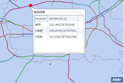
在需要使用Identify功能时,将Map控件的Click事件绑定到Map1_Identify即可。结果如图:
 2、输入起始和终止桩号,要求将其间的路段显示在地图上:
 要解决这个问题,关键是根据两个M值,求的其间一段公路的Geometry。利用的仍然是IRouteLocator2.Locate方法,其中的第一个参数routeLocation,传入的是用IRouteMeasureLineLocation接口定义的“线性位置”,具体可参考帮助文档。
仍然是在LinearRef.svc.cs文件的LinearRef类中,添加以下方法:
[OperationContract(Name = "RetrieveRoutePortionGeometry")]
        ///
        /// used by the client,such as QueryPortion operation, to retrieve the geometry of the route portion
        ///
        /// the route id which the portion is part of
        /// fromMvalue
        /// toMvalue
        /// a json string with specific format,such as [{"x":1111,"y":1111},{"x":2222,"y":2222},{"x":3333,"y":3333}.....]
        public string RetrieveRoutePortionGeometry(string routeid, double fromMValue, double toMValue)
        {
            pServerContext = pSOM.CreateServerContext("shaanxi", "MapServer");
            IRouteLocation routeLoc = pServerContext.CreateObject("esriLocation.RouteMeasureLineLocation") as IRouteLocation;
            routeLoc.MeasureUnit = esriUnits.esriUnknownUnits;
            routeLoc.RouteID = routeid;
            routeLoc.LateralOffset = 0;
            IRouteMeasureLineLocation rMLineLoc = (IRouteMeasureLineLocation)routeLoc;
            rMLineLoc.FromMeasure = fromMValue;
            rMLineLoc.ToMeasure = toMValue;

            IGeometry geom;
            esriLocatingError locError;
            pRtLocator.Locate((IRouteLocation)rMLineLoc, out geom, out locError);

            pServerContext.ReleaseContext();

            //return the routeportion's vertices
            StringBuilder sb = new StringBuilder("[");
            IPolyline pLine = geom as IPolyline;
            IPointCollection pPC = pLine as IPointCollection;
            //json format such as:
            //[{"x":1111,"y":1111},{"x":2222,"y":2222},{"x":3333,"y":3333}.....]
            for (int i = 0; i < pPC.PointCount; i++)
            {
                sb.Append("{\"x\":");
                sb.Append(pPC.get_Point(i).X.ToString());
                sb.Append(",\"y\":");
                sb.Append(pPC.get_Point(i).Y.ToString());
                sb.Append("},");
            }
            //remove the last ","
            sb.Remove(sb.Length - 1, 1);
            sb.Append("]");
            return sb.ToString();
        }
由于在服务器端的AO操作,产生的结果是ESRI.ArcGIS.Geometry.IGeometry类型,而客户端需要的则是ESRI.ArcGIS.Client.Geometry.Geometry类型,所以需要对结果序列化/反序列化,这里采用JSON字符串处理。客户端处理结果的函数仍然放在COperation.cs文件中,如下:
private void LR_RetrieveRoutePortionGeometryCompleted(object sender,LRService.RetrieveRoutePortionGeometryCompletedEventArgs e)
        {
            //create a esri.arcgis.client.geometry.polyline from the coords of points contained in the json string
            string jsonpoints = e.Result;
            JsonArray jsonarrays = (JsonArray)JsonArray.Load(new System.IO.StringReader(jsonpoints));
            ESRI.ArcGIS.Client.Geometry.Polyline line = new ESRI.ArcGIS.Client.Geometry.Polyline()
            {
                SpatialReference = Map1.SpatialReference,
            };
            ESRI.ArcGIS.Client.Geometry.PointCollection pc = new ESRI.ArcGIS.Client.Geometry.PointCollection();
            foreach (JsonObject jo in jsonarrays)
            {
                pc.Add(new ESRI.ArcGIS.Client.Geometry.MapPoint(jo["x"], jo["y"]));
            }
            line.Paths.Add(pc);

            //add a graphic
            Graphic g = new Graphic()
            {
                Geometry = line,
                Symbol = Application.Current.Resources["LineSymbol"] as SimpleLineSymbol,
            };
            glayer.Graphics.Add(g);
}
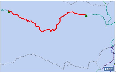
Silverlight中提供了System.Json库,可以非常方便的对JSON字符串进行解析。结果如图:
 3、类似GoogleMap的交通流量地图:
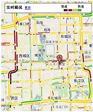
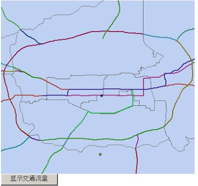
 首先看一下Google的交通流量地图:
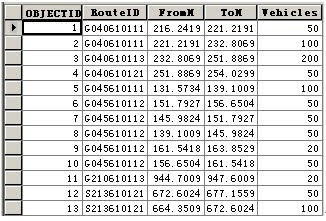
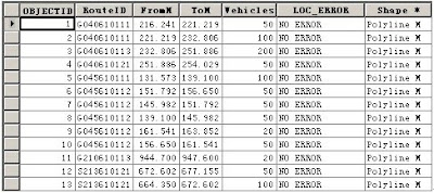
可以看出,之所以能产生不同颜色段,需要的数据有3个:该段的起始和终止M值,该段的车流量。假设我们获取的业务数据表(EventTable)如下:
联想到上面第二个应用场景,我们便想可以获取所有交通数据后,用循环的办法展示出交通流量地图。但这里有两个问题需要思考:1、即使使用IRouteLocator2.LocateRow方法,服务器端根据起止M值解析出所有的分段图形需要一次循环,客户端将这些图形显示出来还需要一次循环,这样是否合理?2、由于结果显示在客户端,不同用户发出请求时,都将重复上面两个循环,如何改进?
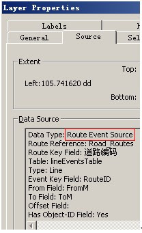
解决问题一:在第二节的Linear Referencing实现原理中,提到了RouteEventSource类,可以将它看作是把Route FeatureClass和EventTable组合在一起的结果,而该类继承自FeatureClass,可当作一个FeatureClass来用。在ArcMap中观察生成后(利用Make Route Event Layer工具)的RouteEventSource层:
不仅包含了EventTable中的事件,还有了我们想要的Shape字段(可取出Geometry)。其实Shape字段中的内容,是利用Dynamic Segmentation技术动态计算出来的。看其图层属性便知,它是在内存中动态生成的:
有了FeatureClass,我们便可以对整个图层进行一次渲染,避免服务器端和客户端的两次循环了。这里要注意,FeatureClass是动态生成的,图层便是动态添加,在地图服务的REST接口中无法暴露出来,也就不能利用客户端API的渲染技术了。
解决问题二:利用SOA的思想,将交通流量图做成一个Traffic服务,不同用户请求时动态添加该服务即可。想想这个服务应该具有的特性:不同时段的交通图,需要动态生成;如果交通图已经生成,则无需重新生成,显示即可。所以我们采取池化方式服务(pooled-service)的特性,刚好解决这一问题。
这个场景我们用Web ADF来实现(客户端API与前两个场景相同)。
首先准备两个Map Service:底图服务:shaanxi,交通流量图服务:ShaanxiTraffic。
后者在ArcMap中打开是这样的:
ShaanxiTraffic服务除了动态生成的交通流量图外,不需要在显示任何信息,所以发布时是空白的;因为动态生成的RouteEventSource将作为图层插入到这个地图服务中,所以Route FeatureClass必须也在这个mxd中才行。
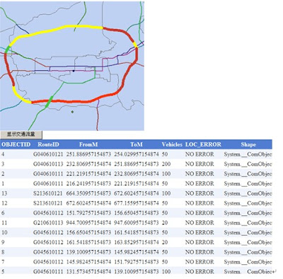
Default.aspx页面中放置一个MapResourceManager控件、一个Map控件、一个CallbackButton按钮和一个GridView控件。先看一下结果:
点击按钮后:
看一下Default.aspx.cs中按钮的点击事件:
protected void CallbackButton1_Clicked(object sender, EventArgs args)
    {
        //先判断Traffic服务中是否已经产生结果
        if (hasTrafficResult())//Traffic服务中已经有结果
        {
            //将结果插入地图
            InsertTrafficService();
        }
        else//服务中还没有结果
        {
            //先生成交通流量结果
            MakeResult();
            //将结果插入地图
            InsertTrafficService();
        }
        //显示RouteEventSource的属性表
        DisplayAttributeTable();
    }
思路都在代码中。依次来看几个函数:
///
    /// 判断池化的Traffic服务中,获取的ServerContext是否已经产生结果
    ///
    /// true or false
    private bool hasTrafficResult()
    {
        ESRI.ArcGIS.ADF.Identity identity = new ESRI.ArcGIS.ADF.Identity("ArcGISWebServices", "yourpassword", "");
        ESRI.ArcGIS.ADF.Connection.AGS.AGSServerConnection agsconn = new ESRI.ArcGIS.ADF.Connection.AGS.AGSServerConnection("machinename", identity);
        agsconn.Connect();
        pSOM = agsconn.ServerObjectManager;
        ESRI.ArcGIS.Server.IServerContext pServerContext = pSOM.CreateServerContext("ShaanxiTraffic", "MapServer");
        ESRI.ArcGIS.Carto.IMapServer2 pMapServer = pServerContext.ServerObject as ESRI.ArcGIS.Carto.IMapServer2;
        ESRI.ArcGIS.Carto.IMapServerObjects2 pMapServerObjects = pMapServer as ESRI.ArcGIS.Carto.IMapServerObjects2;
        ESRI.ArcGIS.Carto.IMap pMap = pMapServerObjects.get_Map(pMapServer.DefaultMapName);
        pServerContext.ReleaseContext();
        return pMap.LayerCount == 1 ? false : true;
    }
对于ShaanxiTraffic服务,在获得的Server Object中,查看当前Map的图层数(默认有一个隐藏的Road图层),若为1则还未产生结果。
下面是动态添加服务的函数,注意要设置背景透明,以便能够看到底图服务:
///
    /// 动态添加服务
    ///
    private void InsertTrafficService()
    {
        if (MapResourceManager1.ResourceItems.Count==1)//若已插入交通流量服务,则不做动作
        {
            MapResourceItem mapResourceItem = new MapResourceItem();
            GISResourceItemDefinition definition = new GISResourceItemDefinition();
            mapResourceItem.Name = "Traffic";
            definition.ResourceDefinition = "Layers@ShaanxiTraffic";
            definition.DataSourceDefinition = "machinename";
            definition.DataSourceType = "ArcGIS Server Local";
            mapResourceItem.Parent = MapResourceManager1;
            mapResourceItem.Definition = definition;
            ESRI.ArcGIS.ADF.Web.DisplaySettings displaysettings = new ESRI.ArcGIS.ADF.Web.DisplaySettings();
            displaysettings.Transparency = 0.0F;
            displaysettings.Visible = true;
            ESRI.ArcGIS.ADF.Web.ImageDescriptor imagedescriptor = new ESRI.ArcGIS.ADF.Web.ImageDescriptor();
            imagedescriptor.TransparentBackground = true;
            imagedescriptor.TransparentColor = System.Drawing.Color.White;
            displaysettings.ImageDescriptor = imagedescriptor;
            mapResourceItem.DisplaySettings = displaysettings;

            MapResourceManager1.ResourceItems.Insert(0, mapResourceItem);
            MapResourceManager1.CreateResource(mapResourceItem);

            if (Map1.ImageBlendingMode == ImageBlendingMode.WebTier)
            {
                Map1.Refresh();
            }
            else
            {
                Map1.RefreshResource("Traffic");
            }

            CallbackButton1.CallbackResults.CopyFrom(Map1.CallbackResults);
        }
    }
MakeResult函数利用ESRI.ArcGIS.Location库来生成交通流量图。由于Traffic服务是池化服务,当第一个用户请求,生成交通流量图后,该实例(servercontext)会返回服务器上而不被销毁,所以下一个用户再次请求时可以直接显示。如果要实现实时的交通流量图,定时在服务器端重生servercontext,并读取当前时段的EventTable即可。
///
    /// 生成交通流量的结果
    ///
    private void MakeResult()
    {
        ESRI.ArcGIS.Server.IServerContext pServerContextTraffic = pSOM.CreateServerContext("ShaanxiTraffic", "MapServer");
        ESRI.ArcGIS.Carto.IMapServer2 pMapServer = pServerContextTraffic.ServerObject as ESRI.ArcGIS.Carto.IMapServer2;
        ESRI.ArcGIS.Carto.IMapServerObjects2 pMapServerObjects = pMapServer as ESRI.ArcGIS.Carto.IMapServerObjects2;
        ESRI.ArcGIS.Carto.IMap pMap = pMapServerObjects.get_Map(pMapServer.DefaultMapName);
        //创建RouteLocator
        IFeatureClass pFC = (GetLayerByName("Road",pMap) as IFeatureLayer).FeatureClass;
        IDataset dS = (IDataset)pFC; // A polylineM feature class.
        IName name = dS.FullName;
        IRouteLocatorName rtLocatorName = pServerContextTraffic.CreateObject("esriLocation.RouteMeasureLocatorName") as IRouteLocatorName;
        rtLocatorName.RouteFeatureClassName = name;
rtLocatorName.RouteIDFieldName = "道路编码";
        rtLocatorName.RouteMeasureUnit = esriUnits.esriUnknownUnits;
        name = (IName)rtLocatorName;
        IRouteLocator2 pRtLocator = (IRouteLocator2)name.Open();

        //创建RouteEventProperties,为RouteEventSource做准备
        IRouteEventProperties2 rtProp = pServerContextTraffic.CreateObject("esriLocation.RouteMeasureLineProperties") as IRouteEventProperties2;
        rtProp.AddErrorField = true;
        rtProp.ErrorFieldName = "LOC_ERROR";
        rtProp.EventMeasureUnit = esriUnits.esriUnknownUnits;
        rtProp.EventRouteIDFieldName = "RouteID";
        IRouteMeasureLineProperties rMLineProp = (IRouteMeasureLineProperties)rtProp;
        rMLineProp.FromMeasureFieldName = "FromM";
        rMLineProp.ToMeasureFieldName = "ToM";

        //创建RouteEventSource
        ITable eventTable = (pFC.FeatureDataset.Workspace as IFeatureWorkspace).OpenTable("lineEventsTable");
        IDataset ds = (IDataset)eventTable;
        IName name2 = ds.FullName;
        IRouteEventSourceName rtEvtSrcName = pServerContextTraffic.CreateObject("esriLocation.RouteEventSourceName") as IRouteEventSourceName;
        rtEvtSrcName.EventTableName = name2;
        rtEvtSrcName.EventProperties = (IRouteEventProperties)rMLineProp;
        rtEvtSrcName.RouteLocatorName = rtLocatorName;
        name2 = (IName)rtEvtSrcName;
        IRouteEventSource rtEvtSrc = (IRouteEventSource)name2.Open();
        //转换到FeatureClass
    pFC = rtEvtSrc as IFeatureClass;

//将RouteEventSource添加到地图中,并进行唯一值渲染
        IUniqueValueRenderer pUVR = pServerContextTraffic.CreateObject("esriCarto.UniqueValueRenderer") as IUniqueValueRenderer;
        pUVR.FieldCount = 1;
        pUVR.set_Field(0, "Vehicles");
        pUVR.UseDefaultSymbol = false;
        IFeatureCursor pFeatureCursor = pFC.Search(null, false);
        IFeature pFeature = pFeatureCursor.NextFeature();
        int ifiledindex = pFC.Fields.FindField("Vehicles");//EventTable中的车流量字段
        while (pFeature != null)
        {
            ISimpleLineSymbol pSymbol = pServerContextTraffic.CreateObject("esriDisplay.SimpleLineSymbol") as ISimpleLineSymbol;
            double value = double.Parse(pFeature.get_Value(ifiledindex).ToString());
            if (value <= 20)
                pSymbol.Color = ESRI.ArcGIS.ADF.Converter.ToRGBColor(pServerContextTraffic, System.Drawing.Color.FromArgb(71, 196, 69)) as IColor;
            else if (value > 20 && value <= 50)
                pSymbol.Color = ESRI.ArcGIS.ADF.Converter.ToRGBColor(pServerContextTraffic, System.Drawing.Color.FromArgb(255, 255, 0)) as IColor;
            else if (value > 50 && value <= 100)
                pSymbol.Color = ESRI.ArcGIS.ADF.Converter.ToRGBColor(pServerContextTraffic, System.Drawing.Color.FromArgb(201, 59, 46)) as IColor;
            else
                pSymbol.Color = ESRI.ArcGIS.ADF.Converter.ToRGBColor(pServerContextTraffic, System.Drawing.Color.FromArgb(250, 52, 17)) as IColor;
            pSymbol.Width = 5;
            pUVR.AddValue(pFeature.get_Value(ifiledindex).ToString(), "Vehicles", pSymbol as ISymbol);
            pFeature = pFeatureCursor.NextFeature();
        }
        IFeatureLayer pFL = pServerContextTraffic.CreateObject("esriCarto.FeatureLayer") as IFeatureLayer;
        pFL.Name = "RouteEventSource";
        pFL.FeatureClass = pFC;
        (pFL as IGeoFeatureLayer).Renderer = pUVR as IFeatureRenderer;

        pMap.AddLayer(pFL as ILayer);//to the 0 index
        pMapServerObjects.RefreshServerObjects();
        pServerContextTraffic.ReleaseContext();
    }
一点注意,在使用IServerContext接口时要及时进行释放。
思考一下:如何通过Geoprocessing Service来实现“交通流量图”?


